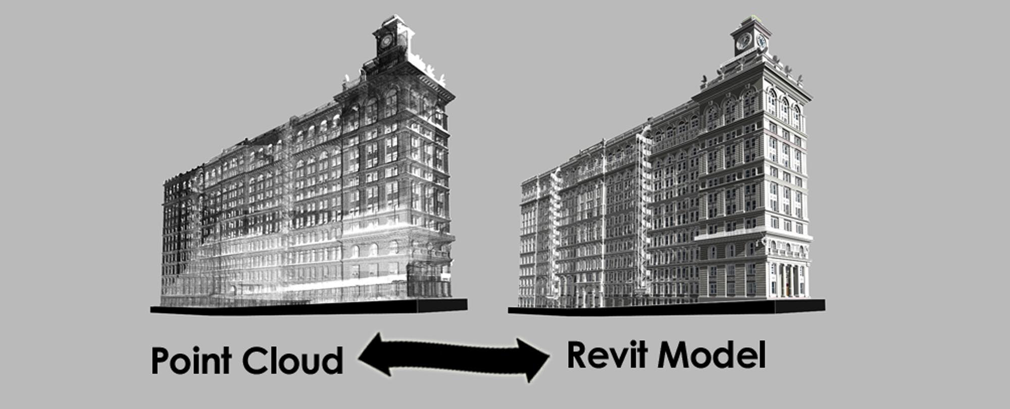
The new technology flourishing its benefits in the modern construction industry is 3D Point Cloud and laser scanning technology. From the renovation and retrofitting to surveying of building, 3D Point cloud is acquiring the fame amongst the Architects and construction professionals. 3D Point Cloud is a database that contains points in three-dimensional coordinate system taken from laser scanning devices. The 3D point cloud is very accurate digital record of an existing object or space.
Laser scanning is the quick way of collecting accurate and precise data about the on-site conditions. Let us explore the advantages of “Scan to BIM” process. What is 3D Point Cloud survey. What Laser Scanning means and the utilization of point cloud data to deliver 3D parametric models.
While surveying the existing structure of buildings, Laser Scanning offers wide range of advantages. It is comparatively quick and exact way of capturing 3D point cloud data. The survey data helps in creating accurate parametric model. Further, this data assists in the design process and helps to make better decisions throughout the project life-cycle.
What is Laser Scanning?
Laser Scanning or 3D Laser Scanning is popularly known as LIDAR (Light Detection and Ranging). This non-contact technology allows the structure of an existing objects or structure to be digitally shot with the help of laser light. This helps to form ‘point clouds’ of data from the surface of an object.
Let’s make clear that the 3D laser scanning is not any magic despite the fact that the technology is quite amazing and advanced. But behind the mirrors, there is lot of know-how and experience that makes laser scanning enriching and easy to Laser Design customers.
This technology has its origin in submarine detection too, but its applications in AEC industry for both Ariel and ground-based surveying are gaining fame.
Working of Laser Scanning
Now, let’s discover the working of laser Scanning technology.
The laser scanner works by rotating a generated laser light at high speed and measuring reflected pulses with a sensor. The scanners can automatically rotate around its axis, and an oscillating mirror moves the beam up and down. As a result, the beam sweeps over the scan area.
When the laser light hits the object, the scanner makes a note of their position about the scanner based on time it takes for each light pulse to be bounced back. As the light moves at constant speed, scanner quickly calculates distance between the scanner and object. Also capturing of the data of the rotating angle and rotating mirror is done. The entire data is termed as “Points.” These points are build up as the devices get to work. And also after more points are collected, an accurate 3D point cloud representation starts emerging. Addition of more point cloud increases the resolution of your scan. Users can also combine photos with scan data. The Laser scanners can capture a massive amount of data.
How to use and manipulate data from a Laser scanning process?
The modulation of generated raw scanned data is done in a software program. This further helps in proper analysis and modeling.
Significantly, import of laser scanned data into the BIM authoring tools such as Autodesk Revit is easy. There are many programs that offer a built-in point cloud system. The data is utilized using the tools and software after introduction of various elements and maintenance of building dependencies.
Benefits of Laser Scanning
- Laser scanning offers several time-saving benefits as follows:
- Laser scanning can collect significantly higher volumes of data in very less time. This helps in quick sharing of survey data as well as helps in speedy discharge of activity on the site.
- Laser scanning offers more complete and accurate project delivery.
- Better off-site fabrication and less on-site modification.
- It helps in faster and cheaper project turnaround, thus reducing the need for site revisions .
Key benefits of laser scanning for various 3D point cloud project phases
Preconstruction
- Laser scanners help in effective visualization of buildings in a virtual environment before actual construction starts. The users can test and understand the full impacts of the decisions before the actual construction.
- Laser Scanners help to take the accurate view of the site prior to construction.
- It offers the key potential to make time and cost savings and also deals with severe conditions on construction sites.
Construction
Laser scanning during the construction phases offers numerous advantages:
- They can quickly check the progress of the project against the initial designs. And, plan according to the footprints, elevations, sections and 3D models.
- The laser scanners are equally handy. Helps in easy fitting of interiors, creating full record scan, 2D floor plan, etc. as construction heads towards the completion.
Post-Construction
A laser scan can promptly delivers data for as-built models. And even helps in future renovation or retrofitting of the buildings.
There are countless uses of laser scanning technology. The uses are not only in architecture industry but also in forensic analysis, forestry, general mapping, and planning. Getting the 3D point cloud data with the help of laser scanning technology is trending in the current scenario. And is proving most-beneficial to the architects and construction professionals.